Monday, June 25, 2012

Mahoosuc Traverse

With one weekend left at home before heading out to Colorado, I thought it would be a good idea to combine some exploring with a long day on my feet with friends. I've wanted to do a complete traverse of the Mahoosuc Range from Grafton Notch State Park in Maine to Gorham, New Hampshire for a couple of years now, but was always a little put off by the long drive and car-spot. After last Saturday, I can say the trip was well worth it.

At roughly 30 miles and 10,000 feet of elevation gain, the Mahoosuc Traverse is in the same league as the Presi Traverse and Pemi Loop, though surely the hardest of the three. For one, it lacks a convenient source of clean water and most will want to bring a treatment method, depending on your comfort level with that sort of thing. Second, this area receives far less traffic than many areas of the Whites and bailing out part way is a bit more difficult. Last, but not least, is the matter of Mahoosuc Notch. Most of the traverse runs concurrently with the Appalachian Trail and the notch is reputed to be the hardest single mile of the AT. We'll go into a little more detail about that later on.

Around 9 in the morning, Farmer, Danger Girl and I  started from the parking lot below Old Speck Mountain in Maine's Grafton Notch State Park.


The trail winds its way up the left side of Eyebrow Cliff, seen below.


Some good rooty trail starts the day off right.


Roughly an hour and a half later we were a few thousand feet higher on Old Speck, enjoying the views. The Baldpates are seen to our west, where the A.T. continues toward its end on Mount Katahdin.


To the south is Sunday River.


To the east: the rest of the Mahoosuc Range, with the Presidentials on the horizon.


To the north: a bunch of stuff I'm not familiar with.


The view up top is aided by a converted fire tower...


...accessed by a steep ladder.


After leaving the summit, we drop down some steep ledges to Speck Pond.


There it is.


Typical White Mountain footing leads onward.


We got a little bit of a view into Mahoosuc Notch up ahead. Talus from the steep cliffs on either side fills the narrow pass with a jumble of huge boulders that we'll be going through.


Along the way we crossed a really pretty stream flowing wide and shallow across rock slabs.


The notch looms ahead and in we go.


Over...


...under...


...and through.


I imagine this is a bit more difficult with an overnight pack.


Looking up the walls of the notch:


Not a lot of sunlight makes it down in here and ice and snow lingers under many of the boulders. In fact, it feels almost air-conditioned and provides a welcome relief from the hot humid June day.


More cliffs. I hear they make for great back country ice climbing.


While the notch really isn't that bad, I can see how it would be very time consuming for backpackers. It's certainly a fun place to visit and worth a trip on its own merits. You certainly don't need to do a full traverse to get there.


After a long, steep climb, we got some really nice views from the open ledges on Fulling Mill Mountain.


I'm no weatherman, but those clouds don't look good.


We took short break at the Full Goose Shelter at mile 10-ish, to filter some water around 1:00 pm.


A little ways later we scrambled up some via-ferrata like stairs.


Back out in the open on some really cool trail through an alpine bog.


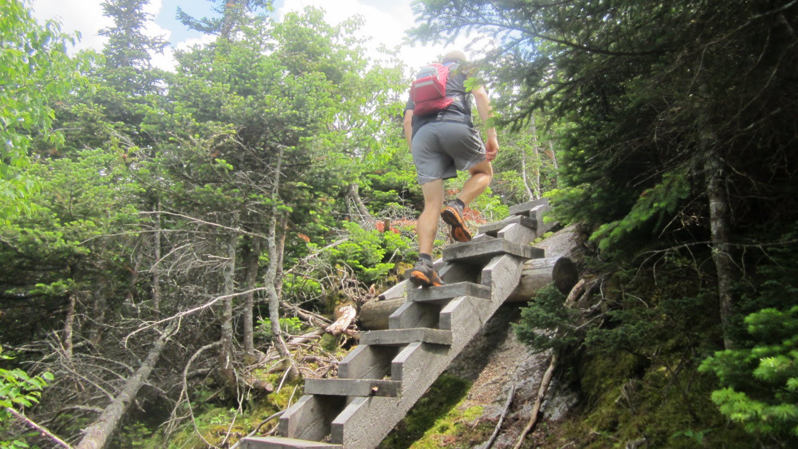
Up some interesting wooden stairs...


...and cool chicken-ramps.


The clouds continued to thicken and we heard thunder off to the north. Luckily, the storm held off while we were out in the open, but it didn't look like a good day to be above treeline on the Presis.


It's been a while since I got that "wow-factor" of a new place in the Whites, but running on Goose Eye certainly delivered. As usual, my words and pictures don't really come close to conveying the feeling as much as I'd like.


Near the top, the clouds rolled in a bit...


...partially shrouding the route ahead.


We then dropped below treeline for a while.


Some more ledgy scrambling, with occasional outlooks.


We arrived at the state line, not quite the halfway point, around 2:30 in the afternoon.


More alpine bog-bridgin' on Mount Success.


Descending to Gentian Pond around mile 20, we got a view of North Baldcap.


We made another stop to filter water near the pond at about 4:10 pm.


Finally, our number was up and the rain rolled in.


It was nothing we couldn't handle, but by now we were ready to be done.


The last ten miles are much more runnable, so the rain didn't cause too many problems over Cascade and Hayes Mountains and soon enough we were back to civilization. Somehow this wasn't the welcome I was expecting, but we slipped through unmolested.


The final stretch of trail lead over a bridge across the the Androscoggin River where my car was waiting.


We finished at about 8:00 pm, for a final time of 10:50, then had many more hours to retrieve the other car and drive home, finally getting to bed after midnight. Another long, long day, but worth it. I'm sure I'll be back.

Monday, June 18, 2012

Racing the Sun - AMC Huts Traverse - 6/16/2012

Gain is the name of the game. With the Hardrock 100 only four short weeks away, my training is going well but needs to be capped off with a couple long days in the mountains with plenty of power hiking. Running around town on lunch break or spending all day zooming around Bear Brook State Park is all well and good, but there's no substitute for specific training. While I could just run repeats up and down Mount Madison, racking up elevation gain 4,000 feet at a time, actually traveling somewhere is much more fulfilling (and the reason I like to do this stuff in the first place). The Hut Traverse, running East-West across the White Mountains for about 50 miles and 17,000 feet of gain, fit the bill perfectly. You can read more about the route herehere and here. While the variation I chose is considered to be the slightly easier "minimal" route, I find that it's the much more aesthetic of the two and I don't feel the need to include Pinkham Notch Visitor Center as a hut. Seriously, why would I spend less time above treeline in exchange for Pinkham, which has powerlines and a parking lot? Sounds like a raw deal to me.

So with the route chosen, I decided to make things a little more interesting. On my previous traverse back in 2010, I started at 2 am (in the dark) and took almost 17 hours to finish. Around these parts in June, the day is about 15 hours long. Why not start at Carter Notch Hut at dawn and race the sun West to Lonesome Lake Hut, trying to finish before sundown? This would allow me to start later (and get more sleep) as well do all of my running on the rocky trails in the daylight. Perfect! With a favorable forecast and a suitably novel plan, my weekend was set.

After a restful night under the stars, I set off on the Nineteen Mile Brook Trail to Carter Notch at 2:35 am, being careful to hike at an easy pace and save energy. It's always kind of cool being in the woods at this time of day; things are very quiet and I have the trail to myself. The sky begins to lighten and I'm left wondering why the birds seem to sing the most at dawn; I don't really notice them as much during the day or in the evening. After reaching the hut I lingered around for a little while, listening to the mice scurry about while a couple Appalachian Trail thru-hikers snored on the floor. I had intended to start at 5, but by 4:30 it was light enough to see well, so I signed the guest book and quietly slipped out the door.


The run back down to Route 16 passed by in a brisk 40 minutes and I was soon jogging up the Great Gulf Trail. This time around I decided to take the Madison Gulf Trail, which is very steep and winds its way up a drainage filled with boulders as big as trucks, then over a few third-class scrambles to emerge above treeline in the col between Mounts Madison and Adams. I took a second to look back toward Carter Notch, where I started, just right of the sign:


I hit Madison Hut at 2:23:36 (1:43:44 from Route 16), signed in and topped off my water. Whatever was being served for breakfast smelled really good, but I needed to boogie onward.


The next stretch on the Northern Presidentials is my favorite part, so I stopped now and again for a few pictures. The view to the north from Thunderstorm Junction:


The Gulfside Trail stretches ahead from cairn to cairn to Mount Washington - my route will then follow the descending ridgeline to the right:


The Cog Railway leading away towards Washington's summit:


Adams and Madison framed by the trestle - what a gorgeous day to be out!


My next stop, Lakes of the Clouds Hut (reached at 4:11:42 elapsed, 1:48:06 from Madison), seen below Mount Monroe in the left side of the picture. My final destination for the day is beyond the high point (Mount Lafayette) on the horizon, with many peaks, ridges, and valleys to cross in between:


The Westside Trail is always a pleasure and makes for some mighty fine runnin'.


At 5:18:37 I reached Mitzpah Hut, back below treeline, in 1:06:55 from Lakes.


Dropping down into Crawford Notch, I could see that I was on a pretty good pace with 5:52:43 elapsed and 34:06 from Mitzpah. While this is roughly the halfway point by distance, it certainly isn't by time. There are several big climbs and many miles of tough trail left go and I think the second half of the Hut Traverse is the harder section.

My roadside stash of goodies  - a smorgasbord of tooth decay!


Just like last time, the steep climb over the Willey Range was a hands-on-knees struggle in the heat of the day. I'd developed a bit of a headache and a couple times was reduced to leaning against a tree while my head spun. Finally cresting over the top of the ridge by Mount Tom, I could switch back to a run down the A-Z Trail and over its rotting bog bridges. It looks like they're planning to replace these soon, as a pile of chopper-delivered lumber was waiting off to the side.


I reached Zealand Hut, with it's nicely framed porch-view, in 7:29:40 and 1:36:57 from Crawford Notch:


The Twinway is another tough section for me and it took 1:26:05 to reach the trail junction on Mount Guyot, in 8:55:45 total time. I stopped for a quick picture of Galehead Hut from South Twin Mountain's summit. I'll need to navigate the tortured ridgeline over Mounts Garfiled (center-right) and Lafayette (center-left):


I finally arrived at Galehead in 9:51:44 and 55:59 from Guyot, quite a bit slower than when I run this section on a Pemi Loop. It was mid afternoon by now, hot and humid, my still head hurt, and I was losing focus enough that fooling around with the camera felt like a good idea:


The view from on top of Mount Garfield, sizing up the route to Lafayette across Garfield Ridge, the trail I love to hate:


Only a steady stream of sugar, salt, and water kept me moving up the last big climb to the crowded summit of Lafayette. Luckily, there was a cool breeze and I started to feel a bit better. Looking back to the East, I'd come so far I couldn't see where I started. Mount Washington was now in the clouds on the horizon:


And looking ahead to the West, over Greenleaf Hut (12:41:27 elapsed, 2:49:43 from Galehead), to my final destination at Lonesome Lake:


I plummeted down the Old Bridle Path, navigating around scrambly ledges and the Levis-and-Reebok-crowd alike, forgetting to hit the split button on my watch as I crossed under the highway in Franconia Notch. By this time it was quite obvious that I'd have no trouble getting to the last hut before sundown, but if I kept pushing I should be able to come in under 14 hours. That seemed like a good goal to focus on, so I alternated between running and hiking on the last section of trail, with a final sprint to reach Lonesome Lake Hut in 1:11:49 from Greenleaf. My final time was 13:53:16, a new personal best by almost 3 hours!

The Lonesome Lake Hut croo was busy preparing dinner and generously offered me a hot heaping helping of turkey and vegetables with a half loaf of bread that I ate so fast I got an upset stomach from not chewing enough. I ended up getting so wrapped up in eating and thinking back on the day that I forgot to take a finishing picture, or any pictures since Lafayette for that matter. After walking back down to the highway, my wife picked me up and we were able to begin the long, tired process of retrieving my car and ammo box before the drive home.

So, I ended up getting exactly what I wanted out of the day. It's one hell of a feeling standing on an open summit and knowing that the horizon is within reach, and a fix I keep coming back for. Additionally, the run was a fun way to engage with the mountains that are a huge part of my life - as well as great preparation and a confidence booster for Hardrock. I'm not too sore and should be able to continue training hard for another week before tapering for the race.