The best thing for this is mountain loops. I prefer them 20-30 miles in length, with 8,000 feet or more of elevation gain and a few peaks along the way. Planned correctly, these loops scratch all the right itches. I get to revisit and explore, make thorough use of the day, blow off some steam, experience a little isolation, and get some training in. I can leave my car in one spot and return to it at the end of the day, no ride needed.
Last Sunday I put together another one of my loops, this time in Waterville Valley. The plan was to park at the Livermore trailhead and run up and over Mount Tecumseh to Tripoli Road, then pass over Mount Osceola and down to Greeley Ponds. From there, I'd link up a few connector trails over to Livermore Road, scramble up the North Slide on Mount Tripyramid, descend the South Slide and run back to the car. This totaled up to about 25 miles, 8,500 feet of gain, and five ranked four thousand footers.
The day started out rather wet and humid from the previous night's rain and I was drenched by the time I summited Mount Tecumseh. It had looked overcast from down in the valley but I got a few views from above the clouds near the top.
Off to the East, I could see the three peaks of Mount Tripyramid, with my afternoon route up the North Slide clearly visible.
The run down off Tecumseh follows an old logging road for part of the way, with good footing and a really mellow grade. A little over a mile on the dirt Tripoli Road and I was working my way up to the outlook on the main peak of Mount Osceola. Below, you can seen the connecting ridgeline that the trail follows over to Osceola's East peak.
Descending off East Osceola is kind of a pain in the ass. The trail is steep, rough, and slick and makes for some slow going down to Greeley Ponds.
At the ponds, the clouds had begun to part a bit and let some blue sky and sun shine through.
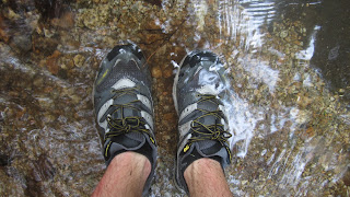
The Greeley Ponds Trail is in pretty rough shape after being washed out by Hurricane Irene last fall. The nearby river has been diverted in a few spots and turned the trail into a streambed.
I had to walk in the water for a few short stretches but otherwise didn't find it to be a big deal.
Here, I made something of a mistake. My original intention was to take the Flume Path and Old Skidder Trail over to Livermore Rd., but I got the urge to explore the Kancamagus Brook XC Ski Trail instead. Both trails go to the same place, so it shouldn't make much difference, right?
Shortly after the junction I found a few old buckets hanging on some trees. Leftovers from logging operations a generation or two ago.
The trail followed an old logging road and was pretty overgrown in many places, but not too difficult to follow. Often the ground was soft underfoot and I would squish through mud up to my ankles.
And then... the old road led into a swamp. One minute I was walking merrily along, the next I was thigh deep in a bog, trying to figure out how to get out without losing my shoes. The farther I went, the worse it got. I tried bushwhacking along the edge of the bog without much luck and was seriously considering turning around, but I only had about a 1/4 mile left to reach Livermore Road, so I ended up just struggling through. You know that scene in the Never Ending Story where the horse sinks into the bog? The experience wasn't far off that.
Finally back on dry land, expressing my regards for XC ski trails in the summer.
While the swamp kind of sucked, the North Slide is always fun. 1400 feet in a half mile up an old landslide? That's more my style.
Part way up the slide you hit some open slabs and can see back towards Tecumseh (left) and the Osceolas (right).
This trail has something of a notorious reputation among hikers but I think you'd be hard pressed to actually fall down it for any significant distance. The bigger danger comes from loose rock and I had to be careful not to dislodge anything on a few people I passed below.
By the time I topped out, I was running pretty low on water. I scooted down the South Slide and was happy to get to a clean stream near the bottom where I could refill my bottles before the last stretch of trail back to my car. Seven and a half hours of peace, quiet, and simplicity and I was ready to face the world again.


I love these reports Adam. You're giving me the itch to get back out to NH and run. It's funny to see your pictures of the steep, rocky trail and know just HOW steep they are even when the pics don't do it justice. I definitely can relate to your thoughts regarding being in the mountains - and running loops.
ReplyDelete"Sometimes the only thing that makes any sense to me is running." Word, brother.
ReplyDelete