Showing posts with label Pemi Loop. Show all posts

Tuesday, June 17, 2014

So Close I Can Smell It: Pemi Loop FKT Attempt - 6/8/14

For me, running the Pemi Loop is an exercise in excessive optimism. I suppose it needs to be. I'm much stronger than last year, surely I can shave off twenty minutes. This thought, a good trail condition report, an excellent weather forecast, and the realization that I hadn't made a visit to the Pemi Loop in over two years led me to make my return. For perhaps the thirteenth time I ran the 50k-ish, 9000 foot course on June 8th with the aim of going as fast as possible and maybe regaining the FKT.

On my last attempt in 2012 I had the benefit of frenzied mountain training for Hardrock, but only managed to shave a token two minutes off my 2011 time. This go 'round, I reasoned I had the benefit of my marathon training for greater leg speed. Plus, I would go lighter than ever before. I'd wear 8-ounce New Balance trail shoes with sticky-rubber outsoles, rather than 12-ounce Brooks Cascadia cinder blocks - feared for their poor grip on wet rock. I finally found a pair of running shorts with good pockets so I could cram in 10 ounces of gel, a small headlamp, and an ultralight windshirt rather than actually carrying a pack. This would force me to use hand bottles for water, with a reduced overall capacity, but would make it easy to refill out of wild water sources on the move. After some research, I've become more comfortable with selectively employing this practice (lots of good information here at Far North Endurance). I'll also say that I wouldn't take such a minimalist approach on a day with any credible threat of poor weather but I then wouldn't be attempting an FKT on those days anyway.
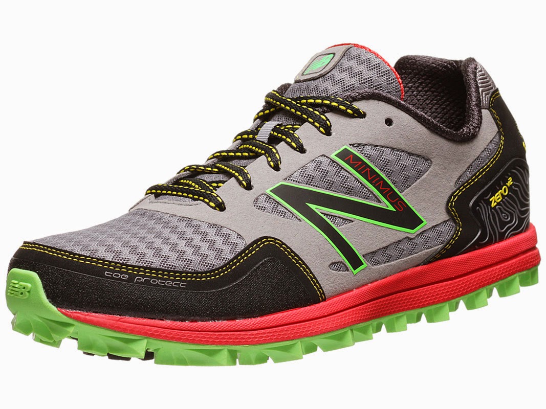
The shoe, Minimus Zero V2

On Pemi-day conditions didn't turn out to be ideal, much more humid and warm than I would have liked, and I struggled more than usual in the final miles. Right now, over a week later, I can recall the damp composting smell of late spring on the Garfield Ridge Trail. It's a little strange to me, but during a hard effort like this I'm left with short, vivid snapshots in my memory from a few particular places and they're not always visual. This one is kind of a distinct Pemi-Loop smell; rotting leaves and moss mixed with B.O. and a whiff of ammonia. Maybe the sound of trickling water and my own labored breathing on the background. That's what I have associated with the the route.

To make a long report short, I cut almost five minutes off my personal best time but came up eleven minutes short of the FKT in 6:38:21. What's spooky to me is how utterly consistent my split times have been, something that can bee seen with a little bit of analysis.


I was nearly dead-nuts on my last two attempts until Galehead Hut, where I pulled ahead of my old times a little. Some time was lost dilly-dallying on Franconia Ridge but I gained it back on the descent of the Osseo Trail from Flume (remember that leg speed thing?). If this were a three-way race I'd have been almost always within sight of my 2011 and 2012 selves for much of the route. This despite several factors in my favor (lighter wight, greater experience) and several factors against me (heat, the generally deteriorating condition of the Bondcliff Trail). Another notable point is that my time to the the junction between the Garfield Ridge and Franconia Brook Trails is a very good indicator of final finishing time, halfway by the clock and accurate to within a five minute margin.


As for the whole water capacity thing, I could have comfortably made it to Garfield Spring with only a single hand bottle. I filled up once on the way up the Bondcliff Trail, then again at the spring where I chugged a bottle and was able to ration my 40 ounce capacity for the rest of the day. I did finally run dry on Mount Flume but at that point I was only 45 minutes from the parking lot and could tolerate a little bit of cotton mouth.

And now I'm left searching for those remaining 11 minutes. This is the best kind of challenge, difficult but feasible. I feel more or less tapped out as far as flat ground and descending speeds go, so I'll need to get stronger on the climbs and improve my stamina. This will mean lots of easy base-building aerobic activity as well as a focus on hill repeats and the like. That combined with a cool, dry day (perhaps this September) and maybe I can get back in the record books, however fleetingly.

What is somewhat gratifying to me is the realization of just how much I've improved since my first Pemi Loop in 2005. If I were to race my 2005 self, I'd be rolling out of my own bed right around the time my slower self left the Lincoln Woods parking lot in the dark. I'd have enough time to make coffee and eat breakfast at home, make the ninety minute drive up North, then pass my old self somewhere on the Twinway. From there, I'd steadily pull away and be home with enough daylight to drink a beer and mow the dandelions on my horribly neglected lawn, all well before dusk, while 2005-Adam would stagger the final few miles down the Wilderness Trail to the car and probably stop at McDonald's on the way home in pathetic desperation. Progress is beautiful thing, regardless of how it relates to the cutting edge of your sport.

GPS Track: http://www.strava.com/activities/151147360

Tuesday, May 29, 2012

Pemigewasset Loop, FKT Attempt - 5/28/2012


One hundred percent effort - an elusive thing if there ever was one. Try as you might, true perfection is nearly impossible to achieve. I find that no matter how well I prepare, how hard I push, how dilligently I try to make tactical decisions, or how good I feel about my latest results, I finish every race knowing I could have done just a little bit better. Truly committed improvement is a continuous process that is never complete. In the case of Pemi Loop, I thought there were a lot of things I could do better. More rest, greater psychological commitment, an additional year of training, and a pattern of declining Pemi PRs led me to believe that there were still gains to be had.

Instead, I ran right into a wall of diminishing returns, but that part comes later...

It's strange being entirely alone yet still having an almost overwhelming feeling of pre race jitters. I was just pacing around nervously at Lincoln Woods by the the interpretive signs but my heart was jack-hammering away, stomach in my throat, all full of butterflies inside, arms and fingers numb with a flood of adrenaline that almost had me shaking. I tried to calm myself by going through my mental checks. Shoes tied tight? Socks not bunched anywhere? Gel and salt packed up? Hydration bladder full and not leaking anywhere? Are you forgetting anything?

The cable suspension bridge over the East Branch of the Pemigewasset River bounced as I ran across and took a right over the decaying railroad ties of the Lincoln Woods Trail, trying my best to stay in control and conserve energy for later. I feel like the extra effort go faster than 7 minutes/mile is largely wasted here and much more economical  gains can be had on the climbs and technical sections. In 35:19, right around last year's split, I took a left onto the Bondcliff Trail and wound my up the Black Brook drainage. As always, the climb was fairly gentle but being sprinkled with sprinkled with loose bowling ball sized rocks makes it more energy intensive than the grade alone would suggest. At the first set of stone stairs I broke into my first real power hike of the day, trying to maintain a rhythm of efficient long powerful strides. Crossing over the summit of Bondcliff in 1:36:41, I noticed that I was less than a minute faster this time.

On the way up Mount Bond proper I encountered a hiker who, seeing me wobble precariously across the talus, asked with concern, "are you limping?"

"Ha! Far from it, thanks."

I smiled and and boogied onward to the Twinway junction with 2:10:55 elapsed, then over South Twin and down to Galehead Hut at 2:53:45. I must have been a bit more cautious on the descent off South Twin because I was over 3 minutes slower and it became increasingly clear that unless I could make up serious time from here on out, I'd have to fight pretty hard just for a personal best, never mind the FKT. Still, I made sure not to waste time standing still and spent less than 60 seconds refilling my bladder inside the hut. The water tap flows nice and fast here

On the way to Mount Garfield I started getting a little worried about the weather. The forecast was for a chance of showers in the afternoon with possible thunderstorms. As the weather cooled off a little and my view to the West was block by Garfield, I started getting a little nervous and started evaluating my bailout options. A couple years ago I made a foolish decision that put me in the middle of a thunderstorm on Franconia Ridge and I'd like to think I've learned my lesson. But, when I topped out on Garfield at 3:47:20, the wind was calm and the skies ahead showed no signs of rain or thunderheads, so I decided to continue on.

Running the Garfield Ridge Trail is always an exercise in focus and patience. If I concentrate on picking out my foot placements several steps in advance and stay in balance, I can move through at a reasonable speed without falling. It can be quite the workout for your core and hips and I was left wondering how this sort of terrain compares that of the Skyrunning circuit that's been making waves in online ultramarathon Hype Machine lately. Specifically, Mike Wolfe's comments here left me pondering if there's some secret technique or training method that the Euros use to cover technical ground. I wish I knew what is was.

Popping out of the trees on Lafayette, I was happy to see a small plane towing a glider. These aircraft are well known regulars, often buzzing quite close to the actual summits of Franconia Ridge, and I presume they're familiar enough with local weather patterns and forecasts that they wouldn't be flying if thunderstorms were threatening. Lafayette's summit was much less crowded than I anticipated, especially for a holiday weekend, and I passed over the top in 4:48:36 elapsed, again within a minute of last year. It was strange, I was feeling much stronger but still couldn't shake my old self in this imaginary race.

I wish the alpine zone in Franconia Ridge was longer, but all too soon I was back into the trees on narrow, slightly overgrown single track. Here I finally managed to make up a couple minutes, mostly because I wasn't out of water and dehydrated this time around, and I hit Mount Flume in 5:57:11. With 5.5 miles and 3,100 feet of descent left to go, I had 30 minutes remaining to beat Ben Nephew's FKT and 49 to beat my old record. The Osseo trail is fast, with a few long stretches that make a sub-7 minute mile feel effortless, so long as your tired quads can take the downhill pounding. I'm always tempted to throw my hands over my head and yell "bbbbBEEEAAAAARrrrrr!!!" as I fly past hikers in this section, but nobody was around this time.

Popping back out on the Lincoln Woods Trail at 6:33:50, I could see that I was much too late for the FKT, but I managed to sustain a good fast run down the old railroad grade. This section always feels like it will never end, whether you're running or hiking, and I've learned to be patient. First, the river gets close to the trail and I'm tempted to start looking for the bridge, but then it gets farther away, and it's only on the second time that you can let yourself believe that you're almost there (for real this time). A hard left onto bridge, a few more tired and ragged steps, and I could finally stop my watch on the far side.

Total time was 6:43:18. While I barely squeaked out a 2:50 improvement, I can't really complain about a good hard day in one of my favorite places. There's not a whole lot else I can think of to improve upon besides just getting fitter. Still, I'm certain that the right person under the right conditions could go well under six hours. It's just a matter of time, and so is my next attempt.

Monday, February 20, 2012

Winter Pemi Loop - 2/18/2012

How many times can you do the Pemi Loop before it gets old? I'm not really sure, but after 8 rounds (in 10 attempts) I'm still having fun. One way to keep things fresh and interesting, as if any trip over Mt. Bond could be dull, has been to make the trip in winter. It's kind of fun to experience all the same trails and peaks at half speed on snowshoes, and something that's only been done in a day a handful of times that I know of.

So with nothing better to do on a February Saturday, I joined my friends Farmer and DangerGirl for yet another lap of the Pemigewasset Wilderness. We departed Lincoln Woods some time around 7:00 am and headed out on the Wilderness Trail.


A couple hours later we popped out above treeline in somewhat breezy and foggy conditions at the infamous  "Hillary Step" just below the summit of Bondcliff. This fearsome 15 foot rock scramble has inspired more than it's fair share of discussion on hiking message boards in the past. Is it class two? Class three? CLASS FIVE ROCK CLIMBING?!?! All I know is that my dog bounds up and down it without assistance.


It's a low snow year, but we did get to jog through some soft powder down to the col on the Way to Mt. Bond. In order to better fit in when we go to Colorado in July, Farmer, DangerGirl and I decided to practice some bro-lingo. Yeah, we're droppin' some freshies down a rad chute into some sweet pow, brah. Shred the gnar! I instantly felt like a total tool and swore never to talk like that again.


The view back to Bondcliff.


We decided to split up for a bit, so while my two companions made the side trip to West Bond I continued down the snowy Twinway on my own.


Still pretty socked in on Mt. Guyot.


After crossing over the summit of South Twin, I made an easy 2.7 mile side trip to North Twin. Apparently someone got a little carried away while painting blazes this summer.


Back on the Twinway I got a good view of Mount Garfield a few miles away; my next stop, after another side trip to Mount Galehead.


By the time I got to Garfield's summit the clouds were beginning to lift a bit and I could see back to the Twin Range where I'd just been. By now I'd been on the move for about 7 hours and I was hit with the realization that if it were summer I'd be back to the car by now.


Somewhere around Garfield Pond I caught up to my friends. The long climb up to the Franconia Ridge looms ahead.


Garfield Ridge Trail in winter just wouldn't feel complete without some trail breaking.


The last bits of sunlight begin fade out on back on the Bonds.


Darkness began to fill the valley below as we near the top of Mount Lafayette.


And we got a semi-cloudy sunset over Cannon Mountain. 


The ridge to Mount Lincoln in twighlight. Several miles ahead, our last peak for the day, Mount Flume is visible left of center.


Farmer and Dangergirl coming up Mount Lincoln with Lafayette behind them. Shortly after this we put on our headlamps and dropped back down into the trees.


From Mount Liberty, the lights of the town of Lincoln down in the valley below. Hot food only a few hours away.


From there on out we just had an easy 5.5 miles of downhill on packed trail under the stars, arriving back at the car around 9 pm. Not a bad way to spend 14 hours with friends.

Monday, June 20, 2011

Pemi Loop - 6/19/2011


The Pemi Loop is a 31 mile enchainment of hiking trails that circumnavigates the Pemigewasset Wilderness in New Hampshire's White Mountains. Some consider it a three to four day backpack, while others complete it in substantially less time. With 9,000 feet of elevation gain and heinous footing, the Loop is a popular test piece for New England mountain runners and hikers.

I've completed the Loop five times over the last five years, with times ranging from 14 hours to 8 hours. Summer, winter, fast and slow - I like it all. Lately, my running abilities seem to have exploded; nearly every race I enter is better than the last one. Nearly every "reach goal" I set for myself is achieved. With that in mind, I decided to run Pemi Loop number six as an all out-out race effort - leave nothing on the table. I figured that this would get me into the low 7 hour range and breaking the 6:47 "fastest known time" was a fantasy. I respect those who've come before me, bit it seemed a bit too audacious to announce any intentions of competing with their times, so I largely kept any record setting ambitions to myself.

At the Lincoln Woods footbridge I stood around for a little bit, I was nervous and had to take a few minutes to gather myself. When my watch said 7:50 I started my GPS and my wrist watch, stepped on to the bridge and started running. The Wilderness Trail is flat and easy and I was able to maintain a 7-8 minute mile pace all the way to the Bondcliff Trail, which I reached in 35:25. From here, the trail mostly takes a gradual uphill with a few stream crossings before steepening higher up. One thing I knew I could do better than on previous runs here was to jog all the shallow uphills. Often, rocky technical footing makes these sections mentally difficult to run, despite their grade. But if I focus on jogging instead of hiking them, there's much time to be saved.

I broke out above treeline to clear skies and a stiff breeze, reaching the Bondcliff summit at 1:37:29. My main strength in mountain running is technical downhills and it felt good to stretch my legs a bit on a gorgeous section of trail before resuming the uphill grind to Mount Bond. Over the top and down the other side brought me to the Twinway junction with 2:12:58 on the clock. From here, much of the trail to South Twin Mountain is runnable and I made sure to keep my effort level up. I reached South Twin's summit at 2:36:13 and then bombed the steep and rough descent to Galehead Hut, arriving at 2:50:09.

I refilled my two liter water bladder in the hut and unpacked a fresh gel flask with only a couple minutes wasted. I knew that I was in a very good position for a strong total time but the hardest section, Garfield Ridge Trail, was ahead. The initial downhills went very fast and I was pleased to find relatively dry trail conditions. On the uphills though, my hamstrings began to twitch and cramp. It was pretty humid and I was sweating alot, with salt starting to feel gritty on my face. I quickly took some more electrolyte pills and was able to fend off any severe cramping. Garfield's summit arrived at 3:46:41.

My time over to Lafayette was a bit slow as I struggled up the steep slabs that lead to the summit, arriving at 4:47:41. Fortunately, I had all the major climbs behind me and I got some physical and mental rest running above treeline on the Franconia Ridge Trail. No matter how many times I go through this place, I still get a boost from the commanding views. I reached Little Haystack in 5:09:11 and dropped back into the trees. Here, my pack began to feel awfully light as I had very little water left.

Late in an intense running effort, my mind tends to get fuzzy and I have a hard time doing math in my head; I became convinced that it was going to take me several hours under the best conditions to get to the end. I felt like I would be lucky to finish in under 8 hours which, combined with some urinary troubles, severely disheartened me. I let my mental discipline slip and began walking on flat sections and shallow uphills that I could have run. Liberty Springs Junction came at 5:39:20 and on the way down Mount Liberty my water ran dry.

I finally reached the top of Mount Flume at 5:58:53. My time was looking a bit better but I thought sub-7 hours was out of reach even though I only had downhill left. My mouth was dry and parched but I bombed down the Osseo Trail knowing that the faster I went, the sooner I could get water. The descent down this trail is the main reason I prefer to do the Pemi Loop counter clockwise, once it joins an old logging road the grade and footing are perfect. It feels almost effortless to go fast here, I just move my legs as fast as I can and let gravity do all the work. Lucky for me, my wife was on her way down from Mounts Flume and Liberty and I took some unplanned support from her in the form of a few gulps of her water.

Much sooner than I expected, the trail began to flatten out. The next thing I knew, I was back to the Wilderness Trail and my watch said about 6:35. Wait... what!? I was under the impression that the Fastest Known Time for this loop was set by Jan Wellford at 6:43. Though that seemed out of reach, I knew I could come close with only a mile of flat trail remaining. I didn't try any heroic efforts on the homestretch and I crossed the footbridge, stopping both watches when my feet hit dirt on the far side. My GPS said 6:46:08 and my watch said 6:46:10. Since I accidentally hit the stop/start button on the GPS at one point, I decided the slightly slower time was most accurate.


It was only on the car ride home that I looked up the previous record time. Last year Jan Wellford ran the opposite direction and got a 6:47:04. I cut less than a minute off that time. Also worth noting is that this is less than half the time my first Pemi-Loop took me back in 2005.