Tuesday, May 29, 2012
Pemigewasset Loop, FKT Attempt - 5/28/2012
One hundred percent effort - an elusive thing if there ever was one. Try as you might, true perfection is nearly impossible to achieve. I find that no matter how well I prepare, how hard I push, how dilligently I try to make tactical decisions, or how good I feel about my latest results, I finish every race knowing I could have done just a little bit better. Truly committed improvement is a continuous process that is never complete. In the case of Pemi Loop, I thought there were a lot of things I could do better. More rest, greater psychological commitment, an additional year of training, and a pattern of declining Pemi PRs led me to believe that there were still gains to be had.
Instead, I ran right into a wall of diminishing returns, but that part comes later...
It's strange being entirely alone yet still having an almost overwhelming feeling of pre race jitters. I was just pacing around nervously at Lincoln Woods by the the interpretive signs but my heart was jack-hammering away, stomach in my throat, all full of butterflies inside, arms and fingers numb with a flood of adrenaline that almost had me shaking. I tried to calm myself by going through my mental checks. Shoes tied tight? Socks not bunched anywhere? Gel and salt packed up? Hydration bladder full and not leaking anywhere? Are you forgetting anything?
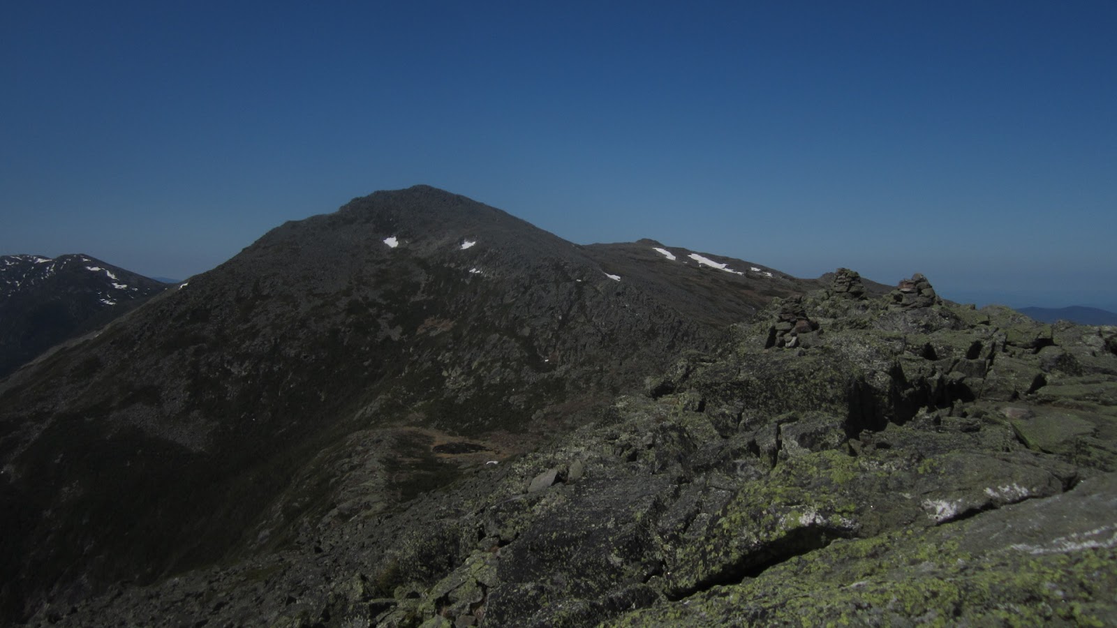
The cable suspension bridge over the East Branch of the Pemigewasset River bounced as I ran across and took a right over the decaying railroad ties of the Lincoln Woods Trail, trying my best to stay in control and conserve energy for later. I feel like the extra effort go faster than 7 minutes/mile is largely wasted here and much more economical gains can be had on the climbs and technical sections. In 35:19, right around last year's split, I took a left onto the Bondcliff Trail and wound my up the Black Brook drainage. As always, the climb was fairly gentle but being sprinkled with sprinkled with loose bowling ball sized rocks makes it more energy intensive than the grade alone would suggest. At the first set of stone stairs I broke into my first real power hike of the day, trying to maintain a rhythm of efficient long powerful strides. Crossing over the summit of Bondcliff in 1:36:41, I noticed that I was less than a minute faster this time.
On the way up Mount Bond proper I encountered a hiker who, seeing me wobble precariously across the talus, asked with concern, "are you limping?"
"Ha! Far from it, thanks."
I smiled and and boogied onward to the Twinway junction with 2:10:55 elapsed, then over South Twin and down to Galehead Hut at 2:53:45. I must have been a bit more cautious on the descent off South Twin because I was over 3 minutes slower and it became increasingly clear that unless I could make up serious time from here on out, I'd have to fight pretty hard just for a personal best, never mind the FKT. Still, I made sure not to waste time standing still and spent less than 60 seconds refilling my bladder inside the hut. The water tap flows nice and fast here
On the way to Mount Garfield I started getting a little worried about the weather. The forecast was for a chance of showers in the afternoon with possible thunderstorms. As the weather cooled off a little and my view to the West was block by Garfield, I started getting a little nervous and started evaluating my bailout options. A couple years ago I made a foolish decision that put me in the middle of a thunderstorm on Franconia Ridge and I'd like to think I've learned my lesson. But, when I topped out on Garfield at 3:47:20, the wind was calm and the skies ahead showed no signs of rain or thunderheads, so I decided to continue on.
Running the Garfield Ridge Trail is always an exercise in focus and patience. If I concentrate on picking out my foot placements several steps in advance and stay in balance, I can move through at a reasonable speed without falling. It can be quite the workout for your core and hips and I was left wondering how this sort of terrain compares that of the Skyrunning circuit that's been making waves in online ultramarathon Hype Machine lately. Specifically, Mike Wolfe's comments here left me pondering if there's some secret technique or training method that the Euros use to cover technical ground. I wish I knew what is was.
Popping out of the trees on Lafayette, I was happy to see a small plane towing a glider. These aircraft are well known regulars, often buzzing quite close to the actual summits of Franconia Ridge, and I presume they're familiar enough with local weather patterns and forecasts that they wouldn't be flying if thunderstorms were threatening. Lafayette's summit was much less crowded than I anticipated, especially for a holiday weekend, and I passed over the top in 4:48:36 elapsed, again within a minute of last year. It was strange, I was feeling much stronger but still couldn't shake my old self in this imaginary race.
I wish the alpine zone in Franconia Ridge was longer, but all too soon I was back into the trees on narrow, slightly overgrown single track. Here I finally managed to make up a couple minutes, mostly because I wasn't out of water and dehydrated this time around, and I hit Mount Flume in 5:57:11. With 5.5 miles and 3,100 feet of descent left to go, I had 30 minutes remaining to beat Ben Nephew's FKT and 49 to beat my old record. The Osseo trail is fast, with a few long stretches that make a sub-7 minute mile feel effortless, so long as your tired quads can take the downhill pounding. I'm always tempted to throw my hands over my head and yell "bbbbBEEEAAAAARrrrrr!!!" as I fly past hikers in this section, but nobody was around this time.
Popping back out on the Lincoln Woods Trail at 6:33:50, I could see that I was much too late for the FKT, but I managed to sustain a good fast run down the old railroad grade. This section always feels like it will never end, whether you're running or hiking, and I've learned to be patient. First, the river gets close to the trail and I'm tempted to start looking for the bridge, but then it gets farther away, and it's only on the second time that you can let yourself believe that you're almost there (for real this time). A hard left onto bridge, a few more tired and ragged steps, and I could finally stop my watch on the far side.
Total time was 6:43:18. While I barely squeaked out a 2:50 improvement, I can't really complain about a good hard day in one of my favorite places. There's not a whole lot else I can think of to improve upon besides just getting fitter. Still, I'm certain that the right person under the right conditions could go well under six hours. It's just a matter of time, and so is my next attempt.
Tuesday, May 22, 2012
Tour de Presidentials
A map of the White Mountain National Forest is like an endless list of possibilities - so many places to go, trails to take, and summits to link up. But when I read the higher summits forecast for last Saturday, there was only one place to be.
In the clear under mostly sunny skies.
Highs: Lower 50s°F
Wind: NW 5-15 mph

The plan was to go from Pinkham to Mount Madison via the Old Jackson Road, Madison Gulf Trail and the Osgood Trail. Then, traverse the Presidential Range over Mounts Adams, Jefferson, Clay, Washington, Monroe, and Boot Spurr and descend the Glen Boulder Trail back to the car - not a bad way to collect 8,000 feet of elevation gain as well.


We took a little side trip to Lowe's Bald Spot to get a good view of Madison (right) and Adams (left) up ahead.

Cooper leads the way...

...but remains patient with me on the steep climb up the Osgood Trail. Along the way we passed by the spot where I experienced something of a motivational meltdown back in March in the wee hours of the morning on one of my biggest goals for the winter. Oh well, the mountains will still be there next winter.

Out above treeline now, looking back down the Osgood Ridge we came up.

And on the top of Mount Madison with Adams up ahead, sporting some lingering snowfields.
The weather was perfect, as advertised, with warm temperatures and only a breath of wind. We stopped by Star Lake for Cooper to have a cool drink.

From there, it was up the Star Lake Trail to Mount Adams. This is the spot where I met my wife in 2005.

Above treeline and exposed to the sun it was actually rather warm. Coop doesn't really like the heat but I had a special surprise for him; the snowfield on Mount Jefferson known as The Beach. Though I haven't personally tried it, wheelbarrowing your face through the snow does seem like an effective way to cool off. Cooper demonstrates:
Clay and Washington ahead, across the Great Gulf.

The view back to Mount Adams, where we came from.

There was another snow patch on Mount Clay.

Wild country down there in the Gulf.

Whiffs of cigarette smoke made it clear that the Cog Railway and Auto Road were open before I actually arrived at the 6,288 foot summit of Mount Washington. Best to not to linger here, so down toward Monroe we go.

A helicopter was busy delivering supplies to Lakes of the Clouds Hut.

From the top of Monroe, Washington looks like it has a battleship parked on top.

The Camel Trail and Davis Path took us over Boot Spur where we encountered throngs of hikers from Quebec - one of the groups had at least 40 people in it. There was some decent running through here and I overheard one of the people I passed say something like "oh, un joggehrrrrrrrrr".

There's nothing quite like open ridge running.

Even the short sections in the trees were pretty runnable.

I think I can see my car from here.

Looking back up at the Glen Boulder.

Once we were well below treeline, the Diretissma took us, sunburned and smiling, back to Pinkham for a total time of 8:15 - not bad considering how much time was spent goofing off.
8+ hours sounds pretty slow for "running" 22 miles but it should still be good Hardrock training and I got to test out a few more equipment options. My LaSportiva Fireblades grip really well but are much too narrow for me to wear in a hundred miler. Still, the mildly uncomfortable fit might be a worthwhile trade for their traction on the wet rock of Garfield Ridge. I also tried out a set of super light carbon fiber Black Diamond Z-poles. They were nice enough for powering up long climbs but just got in the way on faster technical running and I was afraid I'd break them like so many others have (the Z-pole carbon fiber curse).
Sunday, May 20, 2012
Miata Update #2
Way back in 2009 I started working on restoring an old Miata. Well, 1990 isn't all that old, but the car has significant sentimental value to me and was beginning to show its age, so I thought it would be a fun project to take on. I initially started taking things apart and even posted a few pictures in blog posts, but the project soon stalled as projects like this are prone to do. It's a whole lot easier to take things apart than to put them back together.

But In the last year or so I've resumed work and gotten a decent amount accomplished, mostly in fits and spurts when time has allowed, but I'm getting there. Again, like most projects, this has taken on something of a life of its own and the time frame has dragged out way beyond my original intentions. So, In the interest of posterity (and accountability), I figured I'd document the progress I've made.
First I had to fabricate a new sheet metal patch for the hole in my rocker panel where I cut out some substantial rust. With the help of my friend Sean, I cut a pattern out of the side of a PBR box.

Then we cut out a corresponding piece of sheet metal and bent it to match the shape of the rocker panel.

Not too bad, considering our methods.

Then we bonded the panel in place using a structural automotive epoxy. This should be just as strong as welding without requiring nearly as much equipment, training, or the risk of warping or burning anything.

After letting that cure for a couple days, I got to work filling in the gaps around the repair panels.

Then sanding the filler to smooth things out.

With some primer over the top, it doesn't look half bad. At least there isn't a hole there anymore.

I also filled in my radio antenna hole, because the car will look less cluttered without one and radio sucks anyway.

With some careful smoothing, it should look like there was never an antenna there at all.

I also did a bunch of other bodywork removing my rear badges and filling the holes...

...and replacing the passenger door. The old one had a rust hole and some pretty bad dents. The donor door was a little better, but still needed significant refinishing.

Then I moved on to the rest of the body and fenders. Sometimes you have make things worse before you make them better.

Ready for primer.

Now we're making progress.

It's like a mobile, but with car parts.

Looking a bit better with the blue paint on. I decided to go with a single stage paint in the original Mazda Mariner (smurf) Blue.

More flying body parts.

My first attempt at spraying the color coat came out rather poorly, proving what I knew all along: I am a mechanical engineer, not a body shop technician. This ripply texture is what's known as "orange peel". It looks like shit and I had to sand most of it and off start over.

The second attempt went a bit better, but I'll still have to do lots of wet sanding to smooth things out.

In the mean time I also dyed my seats so they'd be black instead of sun-faded grey.

Before is on the right, after on the left.

The rest of the automotive family is there to offer support.

We can rebuild (her).

Hopefully more progress to come soon.
Friday, May 18, 2012
Wapack 'n Back 50 Mile
You wouldn't think of southern New Hampshire as the kind of place that would be home to one of the toughest fifty mile ultramarathons around. The hills and mountains don't really stick out on the horizon all that much and most attention gets paid to the more prominent Mount Monadnock to the West and the much taller White Mountains to the north. However, running along the ridgeline divide between the Merrimack and Connecticut River watersheds is the Wapack Trail, a 21.5 mile hiking trail that's surprisingly rugged. The Wapack and Back 50 mile course does an out and back along the entire length of the trail, with an additional 7 mile leg thrown on at the end for good measure. Despite the fact that there are no sustained climbs over a thousand vertical feet, runners will have racked up about 12,000 feet of cumulative elevation gain by the time they complete a full 50 miles as result of the relentless steep ups and downs. To make things even more interesting, much of the footing on the Wapack consists of open ledges, shattered rock, mud, and roots that the Massanutten 100 would envy.

For the last two years I've volunteered as an aid station worker at Wapack, but for 2012 I figured it was about time for me to take a turn to run it myself and see what I could do. The course record of 9:57 had stood since 2008 and I figured that that was just about long enough. With a decent amount of training on the course, I figured that I had a good shot at going well under 10 hours. At the same time, I'd be using the race to test out a few equipment options for Hardrock, get my longest training run of the year in, and try not to push so hard that I'd have to seriously interrupt my training schedule for recovery.
This time of year it's just barely light enough to see well at 5:00 am, so that's when we started. I headed up Mount Watatic in the lead group of five runners before settling into a more comfortable pace as Josh Katzman and Eric Ahern boogied on ahead. Still, I kept up a decently strenuous pace with my heart rate in the 160s - running the downs, flats, and shallow uphills and hiking the steeper parts. Ryan Welts and Ben Thompson were with me over the open ledges of Pratt Mountain above Binney Pond where we enjoyed great views of the rising sun to the east and Mount Monadnock to the west. By the time we passed through the mile 9 aid station at Windblown it was down to just Ryan and I moving at a very similar pace. I've been running with Ryan for a couple years now and our abilities have always been closely matched, despite the fact that we both keep improving year after year.


While I was able to hang with Josh on the technical downhills, as soon as we hit the steeps for North Pack, I felt a little over-strained for this point in the race and let him run on ahead. Still, when the turn-around appeared at mile 21.5 in 3 hour 45 minutes, Josh was just barely leaving the aid station. This would prove to be a pattern for much of the rest of the race - Josh would gradually pull away while actually running, only to have me catch up at the aid stations. While not realistically able to challenge Josh for the win, I was glad to make him work a little for it. On the way back over North Pack I got a good look at who was behind me and how close they were. I was happy to have a decent lead over Eric, Ben, and Justin Contois, but not so much that I could relax.
By now it was mid-day and the temperatures were reaching the upper 70s. Unlike the TARC 50K two weeks ago, I made sure to stay on top of my hydration and it seemed to pay off. While I did get some mild dizzy spells and nausea, it was only enough to be uncomfortable, not like some of the more serious symptoms I've had recently. To add a bit of insult to things though, I squeezed my gel flask a bit too hard while trying to eat and had the nozzle pop off in my face, leaving a sticky gel mess all over my chin and hands. Gross. The sad thing is that this is not the first time I've had this happen and I may just go back to gel packets to avoid it.
The hardest part of Wapack, I think, is the 7 mile out and back. Once you've returned back to the start/finish at mile 43, you still need to head back up over Mount Watatic for 3.5 miles, then turn around and come back a final time. With lots of food and an inviting car close by, it would be easy to call it day and relax. But, even though I was in second place, there was still over two hours left to go under the old course record, so back out I went.

By this time I knew there was almost no chance of actually catching Josh but I still put in an honest effort the whole way. There were a few opportunities to heckle my friends Justin Contois and Kristina Folcik, both on their way inbound, that I took full advantage of. It must have worked because I wasn't able to catch Justin before he hit the finish area (mile 43 for him). The trip back went by quickly and I ran around the gate that serves as the finish line in 9:20, 37 minutes under the old course record and about 15 minutes behind Josh.
I think the most enjoyable part of the whole day was just hanging out at the end chatting with friends, basking in the sun, and cheering people in. To top it all off, Ryan proposed to his girlfriend Kristina, which just added to the general feeling of happiness and contentment. This might not be the most high profile race around, but damn was it fun.


For the last two years I've volunteered as an aid station worker at Wapack, but for 2012 I figured it was about time for me to take a turn to run it myself and see what I could do. The course record of 9:57 had stood since 2008 and I figured that that was just about long enough. With a decent amount of training on the course, I figured that I had a good shot at going well under 10 hours. At the same time, I'd be using the race to test out a few equipment options for Hardrock, get my longest training run of the year in, and try not to push so hard that I'd have to seriously interrupt my training schedule for recovery.
This time of year it's just barely light enough to see well at 5:00 am, so that's when we started. I headed up Mount Watatic in the lead group of five runners before settling into a more comfortable pace as Josh Katzman and Eric Ahern boogied on ahead. Still, I kept up a decently strenuous pace with my heart rate in the 160s - running the downs, flats, and shallow uphills and hiking the steeper parts. Ryan Welts and Ben Thompson were with me over the open ledges of Pratt Mountain above Binney Pond where we enjoyed great views of the rising sun to the east and Mount Monadnock to the west. By the time we passed through the mile 9 aid station at Windblown it was down to just Ryan and I moving at a very similar pace. I've been running with Ryan for a couple years now and our abilities have always been closely matched, despite the fact that we both keep improving year after year.

When we rolled into Miller State Park at mile 16, I was surprised to learn that the leaders, Josh and Eric, hadn't come through yet - they must have taken a wrong turn somewhere. Before I'd finished filling my water bottles they both came into the aid station, having finally found the crucial turn off from the descent down Temple Mountain. Ryan and I took off up the rockiest section of the course to Pack Monadnock with Josh closely following. On the descent down the other side, Ryan fell back with a troublesome quadricep issue. I would later learn that he turned around and walked back to Miller in considerable pain to drop out of the race.

While I was able to hang with Josh on the technical downhills, as soon as we hit the steeps for North Pack, I felt a little over-strained for this point in the race and let him run on ahead. Still, when the turn-around appeared at mile 21.5 in 3 hour 45 minutes, Josh was just barely leaving the aid station. This would prove to be a pattern for much of the rest of the race - Josh would gradually pull away while actually running, only to have me catch up at the aid stations. While not realistically able to challenge Josh for the win, I was glad to make him work a little for it. On the way back over North Pack I got a good look at who was behind me and how close they were. I was happy to have a decent lead over Eric, Ben, and Justin Contois, but not so much that I could relax.
By now it was mid-day and the temperatures were reaching the upper 70s. Unlike the TARC 50K two weeks ago, I made sure to stay on top of my hydration and it seemed to pay off. While I did get some mild dizzy spells and nausea, it was only enough to be uncomfortable, not like some of the more serious symptoms I've had recently. To add a bit of insult to things though, I squeezed my gel flask a bit too hard while trying to eat and had the nozzle pop off in my face, leaving a sticky gel mess all over my chin and hands. Gross. The sad thing is that this is not the first time I've had this happen and I may just go back to gel packets to avoid it.
The hardest part of Wapack, I think, is the 7 mile out and back. Once you've returned back to the start/finish at mile 43, you still need to head back up over Mount Watatic for 3.5 miles, then turn around and come back a final time. With lots of food and an inviting car close by, it would be easy to call it day and relax. But, even though I was in second place, there was still over two hours left to go under the old course record, so back out I went.

By this time I knew there was almost no chance of actually catching Josh but I still put in an honest effort the whole way. There were a few opportunities to heckle my friends Justin Contois and Kristina Folcik, both on their way inbound, that I took full advantage of. It must have worked because I wasn't able to catch Justin before he hit the finish area (mile 43 for him). The trip back went by quickly and I ran around the gate that serves as the finish line in 9:20, 37 minutes under the old course record and about 15 minutes behind Josh.
I think the most enjoyable part of the whole day was just hanging out at the end chatting with friends, basking in the sun, and cheering people in. To top it all off, Ryan proposed to his girlfriend Kristina, which just added to the general feeling of happiness and contentment. This might not be the most high profile race around, but damn was it fun.

Subscribe to:
Posts (Atom)